
California’s Salton Sea has been drying up for years. Can the proposed infrastructure projects help save it?
Time is running out to come up with a plan to save the Salton Sea. Water levels in California’s largest lake continue to drop, subjecting nearby communities to harmful levels of toxic dust stirred up from the dry, exposed lakebed.
For more than a century, the shallow lake has been a beneficiary of the Colorado River water that feeds the nearby Imperial Valley farm fields. As water was sold off and diverted, more than 15,000 acres of lakebed containing years of fertilizer and pesticide runoff were exposed to the air and desert winds.
The dwindling water supply increases the lake’s salinity, killing off fish, destroying once-lush migratory bird habitats and making children sick from the airborne toxins stirred up in the dust.
The California Natural Resources Agency was tasked with coming up with a long-term fix by the end of 2022, and 11 plans on the table focus mainly on one big idea: pulling in water across the U.S.-Mexican border from the Sea of Cortez north to the Salton Sea. Some proposals are more ambitious than others, envisioning tourism and shipping industries popping up along the desert canal.
Though full costs are unknown, fixing the Salton Sea arguably would be the biggest North American water project since the construction of the Hoover Dam in the 1930s.
What’s happening to the lake?
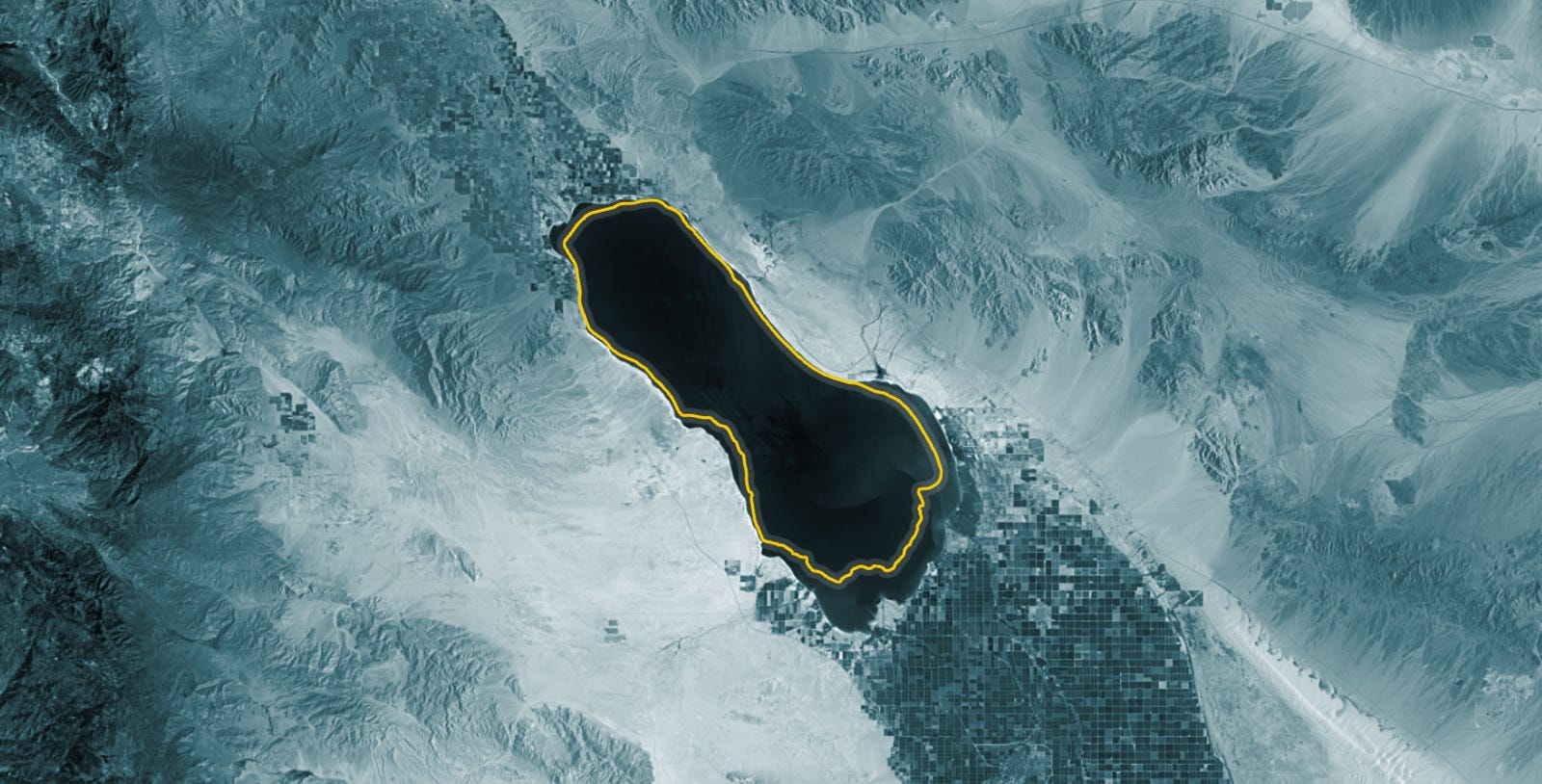
The modern Salton Sea – which has filled several times before – formed in 1905, when floodwaters from the Colorado River to the east breached an irrigation canal and dumped into a low-lying area called the Salton Sink, a depression in the desert that formed the lower basin of the ancient prehistoric Lake Cahuilla.
In the hundred years since the lake formed, it’s been sustained by agricultural runoff and became a rare stopover point for migratory birds traveling the Pacific Flyway.
As the Colorado River water has been transferred from the farms neighboring the lake to growing urban areas, the Salton Sea’s footprint has shrunk.
The satellite images below show the impact:
A model released by the U.S. Bureau of Reclamation in 2015 shows what the lake footprint could be in 2035 with no remedial efforts to reverse the lake’s fate.
Effects of a shrinking lake
Two major forces affecting the lake’s health are its loss in water level and the sharp increase in salinity, which is twice as high as the ocean. Since 2000, the Salton Sea’s surface elevation has dropped more than 10 feet, and more than 15,000 net acres of dry lakebed, known as playa, have been exposed.
The salinity levels of the water kill off fish populations, resulting in fewer fish-eating birds such as pelicans and cormorants. Many birds have died of hunger.
As the Salton Sea dries up, the health toll on humans is alarming. Imperial County more than doubles the rest of California in the rate of asthma-related emergency room visits among children ages 5-17.
Any successful plan to save the Salton Sea will need to reverse these trends while providing economic benefits to offset the huge costs.

Possible routes for a sea-to-sea fix
The most commonly discussed idea is to build a canal across the U.S.-Mexican border that connects to the Sea of Cortez, 125 miles to the south, and import water to the Salton Sea. By comparison (although much more narrow and shallow), a sea-to-sea canal would be more than twice as long as the Panama Canal.
Such a sea-to-sea route has been promoted by businessman Gary Jennings, a founding partner of the Sea to Sea Canal Co.
Another proposal submitted by Agess Inc. includes flooding 142,000 acres of a dry lakebed in Mexico called Laguna Salada and creating economic development in Baja California.

Sending ocean water across the desert wouldn’t be an easy fix, and any plan would need to negotiate agreements with a variety of stakeholders on both sides of the international border with Mexico. Even carefully laid routes would need to traverse private land, communal farmlands and Cucapá territory. On top of the permitting and treaty hurdles, an exact dollar amount isn’t known, but estimates have suggested costs for a canal project would range into the billions of dollars.

Related Posts
Tags
Share This


Follow Us!