
How Growth-Focused Politics Helped Build Vulnerability in Louisiana’s Flood Zones

Updated | As coastal communities from the Carolinas through New England track Tropical Storm Hermine, which struck Florida yesterday as that state’s first hurricane since 2005 before weakening, it’s worth looking back at the disastrous deluge in Louisiana for wider lessons. A good starting point is two photographs.

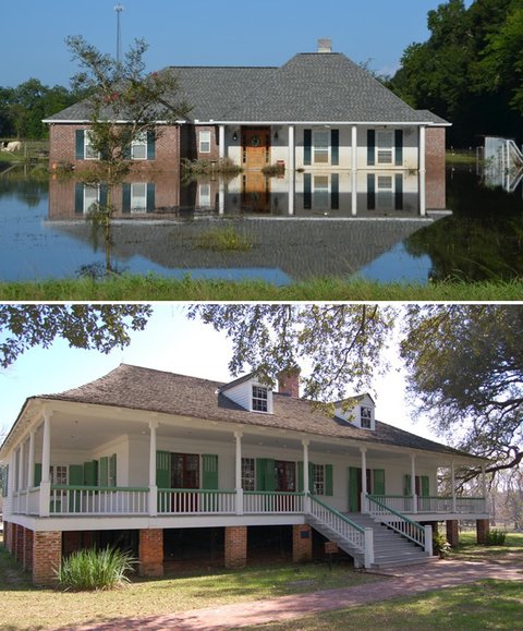
What’s wrong with these pictures?
When the elegant plantation home was built in Baton Rouge, La., some two centuries ago, it was elevated a few feet aboveground — providing greatly boosted odds of limited damage in one of the Mississippi delta’s frequent big floods (not to mention protection from termites and the like).
When the contemporary ranch was built in a development in Ascension Parish nearby, it was set on a concrete slab — deeply vulnerable to floodwaters like those that came in the state’s astounding mega-rainfall in mid August. The photos were taken by Craig E. Colten, the Carl O. Sauer Professor of Geography at Louisiana State University and a longtime student of why communities expand in harm’s way.
He wrote a compelling piece for The Conversation digging in on the growth-oriented policies and perverse incentives that added greatly to the losses in Louisiana’s great flood of 2016.
You can read an excerpt below.
But I also recommend you read a deep dive into factors behind the scope of losses in the August flood, by Edward P. Richards, who directs the program in law, science and public health at Louisiana State’s law school. That piece includes some helpful math and flood history explaining why “one in a thousand year” storm labels or the like can greatly overstate the rarity of extreme events.
Here’s his prime point in a section under the heading “Who’s to blame?”:
From a land use perspective, the primary problem was that local planning and zoning commissions have known that the areas are prone to severe flooding for at least the 30-plus years since the 1983 flood. Homeowners and small businesses were not warned about the risk and were not advised to buy flood insurance if they were outside the FEMA 100-year flood zone. They relied on planning and zoning commissions to determine if developers were building in safe locations.
After surveying the situation in Louisiana’s flood zone, Richards offers an all-too-familiar warning to growth-oriented municipalities in flood zones around the country:
This is a problem for every community in the United States that is subject to periodic flooding. There are many communities with millions of homes that have built themselves beyond the drainage capacity of their watersheds and face the same difficult choices about development and relocation as does the area currently flooded in Louisiana.
[Read John Schwartz’s new exploration of tropical storms in a warming climate. And for a discussion of factors that fueled the massive rains in Louisiana, including the role of greenhouse-driven climate change, click back here and listen to the related Warm Regards podcast.*]
Read further on, if you dare, and you’ll find a hair-raising nugget from Katherine Bagley’s piece for Yale Environment 360 on a new study of “severe repetitive loss properties,” rebuilt over and over and over and over again (actually many more times than that for some) thanks to subsidized federal flood insurance:

In Colten’s piece, “Suburban sprawl and poor preparation worsened flood damage in Louisiana,” the geographer describes some parallels with the devastation wrought by Hurricane Katrina:

In both cases, human decisions magnified the consequences of extreme natural events. Planning and permitting enabled development in areas that had experienced repeat floods, and agencies had failed to complete projects designed to mitigate flood damage before the storms hit.
This part of Louisiana, which is known as the Florida Parishes because it once was part of the Spanish territory of Florida, is a natural laboratory for flood studies. A benchmark flood in 1983 caused some $344 million in damages. Additional dramatic floods occurred in 1990 and 1993. In 2001 Tropical Storm Allison dumped 19 inches of rain on Baton Rouge over the course of two days and unleashed extensive inundations. And just last March, 9 to 15 inches of rain inundated much of the same area.
In 1985 Rod Emmer, the long-time director of the Louisiana floodplain managers’ association, gave a stunningly prescient presentation to a national gathering of floodplain managers in New Orleans. Emmer observed that the devastating 1983 flood along the Amite River was the fourth in an 11-year span, and that losses could have been reduced with sensible flood-reduction projects. He also pointed out that planners had repeatedly called for such action, and concluded that the problem was not a failure to plan, but a failure to follow through and complete projects.
After the 1983 flood, local officials began taking steps to improve flood protection systems and reduce risk. They included raising and modifying highway bridges that impeded the flow of river water, and upgrading levees and pumps to manage excess backwater flooding in the lower reaches of the river basins.
Baton Rouge, the state capital and largest city in the region, and Denham Springs modified their floodplain building standards to reduce risk. And public officials secured authorization in 1986 for the Corps of Engineers to build a diversion canal to redirect excess water from the upper Comite River basin to the Mississippi. Local voters even approved a tax to fund a portion of the project in 2000. By all appearances, it seemed that communities were responding to Emmer’s appeal.
However, these efforts have not been sustained. Suburban sprawl has spilled onto floodplains and placed residents at risk. For example, the relatively new incorporated community of Central in East Baton Rouge Parish reports that 75 percent of its territory is in the 100-year floodplain. According to initial news reports, up to 90 percent of the town’s houses sustained damage in this month’s floods. Between 2000 and 2010, the population of Ascension Parish grew from 76,617 to 107,215, and Livingston Parish’s population increased from 91,814 to 128,026. Developers have intensively built up areas along the Comite and Amite rivers and in the territory where the two rivers converge and back up into Bayou Manchac during floods….
There has been no effort to deflect development or require safe construction practices within the 500-year floodplain, even though the region’s flood history suggests that broader flood mitigation efforts would be prudent.
Since Congress passed the Disaster Relief Act of 1950, the federal government has provided relief and recovery funds after large-scale floods and other disasters. These payments, along with federally funded levees and other flood control structures, have created a false sense of security in the face of risk.
As promised, if you have the strength, here’s the main finding from the Natural Resources Defense Council report on repetitive flood losses — and bailouts — at the heart of Bagley’s story (italics added by me):
2,100 properties across the U.S. enrolled in the National Flood Insurance Program have flooded and been rebuilt more than 10 times since 1978, according to a new analysis of insurance data by the Natural Resources Defense Council (NRDC). One home in Batchelor, Louisiana has flooded 40 times over the past four decades, receiving $428,379 in insurance payments. More than 30,000 properties in the program, run by the Federal Emergency Management Agency, have flooded multiple times over the years. Those homes, known as “severe repetitive loss properties,” make up just 0.6 percent of federal flood insurance policies. But they account for 10.6 percent of the program’s claims — totaling $5.5 billion in payments….
According to FEMA records, Louisiana homeowners with flood insurance have poor track records when it comes to preparing for the next storm. The state leads the nation in severe repetitive loss properties, with more than 7,200 of the NFIP’s 30,000 multi-flood homes. Since 1978, these Louisiana houses have received $1.22 billion in flood insurance payments — 22 percent of all repetitive loss claims, according the NRDC.
“We need to change the emphasis of the NFIP from a rebuilding program to a risk mitigation program,” said Moore. “It currently addresses people’s short-term need to get their life back in order, not the long-term risk.”
I can’t end without noting how much Moore’s plea echoes those I’ve been hearing from officials, economists and scientists in the West’s crowding wildfire zones, where ballooning federal budgets for fighting fires are draining money from programs that could help communities build safer and get comfortable “living with wildfire.”
Further reading | For a sobering reminder of just how normal massive flooding is along the Mississippi and its delta, explore the studies linked in another post by Richards at the L.S.U. law school:
“Mississippi River Flood History”
The record of Mississippi River floods goes back to the earliest explorers: High Flows and Flood History on the Lower Mississippi River Below Red River Landing, LA (1543 – Present) and the paleoclimate records show megafloods greatly exceeding even the 1927 flood: Brown, P., J. P. Kennett, and B. L. Ingram (1999), Marine evidence for episodic Holocene megafloods in North America and the northern Gulf of Mexico, Paleoceanography, 14(4), 498–510, doi:10.1029/1999PA900017; and Tripsanas, E.K. et al., 2013. Paleoenvironmental and paleoclimatic implications of enhanced Holocene discharge from the Mississippi River based on the sedimentology and geochemistry of a deep core (JPC-26) from the Gulf of Mexico. Palaios, 28(9), pp.623–636.
___
Related Posts
Tags
Share This


Follow Us!